

The Atherton Tableland is a plateau and highlands in Far North Queensland, Australia, and is also known as Cairns Hinterland. Cairns International Airport provides the main transport hub for the region.
The area generally referred to as the Atherton Tablelands, actually consists of three tablelands - the Hann Tableland, Atherton Tableland, and Evelyn Tableland, along with parts of the Australian Outback in the west.
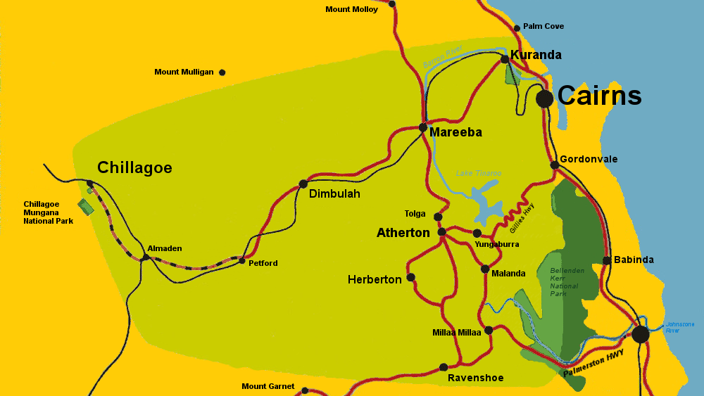
The largest towns on the tablelands are Atherton and Mareeba. Smaller towns and villages, include Kuranda, Yungaburra, Malanda, Millaa Milla, Tolga, Herberton, and Ravenshoe.
Each town has its own distinctive character shaped by its history, environment, and the industries that brought it into existence and sustained its economy.
Malanda and Millaa Millaa are centers for dairy farming in an area of high rainfall and rainforests. Herberton and Irvinebank are former mining towns situated in dry, rugged, rocky mountain ranges. Ravenshoe began as a cedar getting camp and was sustained by the timber trade for much of its history.
The environment of the Atherton Tabelands changes rapidly according to altitude, and distance from the coast. The eastern coastal ranges are covered in wet tropical rainforests recognised by UNESCO as having World Heritage status. Remnants of the forests on the tablelands are managed as national parks. Notable natural attractions include the twin Crater Lakes - Lake Eacham and Lake Barrine, the Curtain Figtree, the Mt Hypipamee Crater, the waterfalls of Millaa Millaa, and many more.
Visitors from afar have been attracted to the Atherton Tablelands for more than a century. The picturesque scenery and natural attractions are supplemented by a comfortable climate. Despite its location in the tropics, the altitude of the Tablelands makes it cooler and less humid than the coastal plains.
The main economy of the Atherton Tablelands today is agriculture. Lake Tinaroo, formed by damming the Barron River near Yungaburra, provides water for irrigation schemes around Mareeba and Dimbulah. Lake Tinaroo is also used for recreational activities such as barrumundi fishing and boating.
The agricultural products of the Atherton Tablelands include dairy products, beef, potatoes, sugar-cane, coffee, tea, and tropical fruits. As well as a milk and butter factory at Malanda, there are boutique cheeseries and locally produced yoghurts. In recent years some agricultural businesses have combined tourism by offering accommodation, farm and processing tours, and restaurants and cafes featuring their products.
Renewable energy has been generated on the Atherton Tablelands since the 1930s, and today the region is the site of an increasing amount of green energy projects, including wind, water, and solar power plants, as well as on-farm and refinery products to generate electricity.
Indigenous Australians have occupied the Atherton Tablelands for tens of thousands of years. At the time of European arrival, the eastern, rainforest-covered part of the tableland was the home of the Djirrbal and Ngadjonji tribes. The coming of white settlers caused great disruption to the aboriginal traditional way of life. Read more history of the Atherton Tablelands
Atherton Tableland Netguide ©1998 Last update December 20, 2023 Privacy Policy About Us Contact-Us